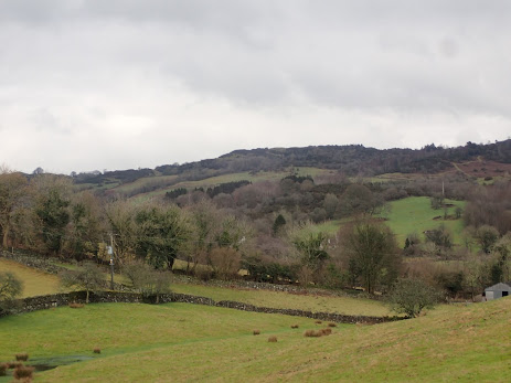
History of the land: Gilpin Valley and Starnthwaite , South Cumbria
Using information about the long term history of the South Lakes and what is known about local villages from publicly available sources this is what I now know about the plot that is now Bel’s Wood. I have given the links I have used and am particularly grateful to the Crosthwaite & Lyth Valley website which gives a good long term history or the area with illustrations - link here https://www.crosthwaiteandlyth.co.uk/html/cameos/cameochapter3.php
The plot is in the Gilpin Valley carved out by the River Gilpin which appears to rise in the Gilpin Plantation to the north. This flows south and briefly joins the River Kent before it arrives into the sea feeding Morecambe Bay.
The hamlet of Starnthwaite is the closest settlement.
The ancient history of the Lake District shows that the land has been occupied initially by Neanderthals (130,000 BC) and then after the ice age by Homo Sapiens circa 12,000 BC. A warmer climate led to forestation of the land.
From 5,500BC the clearing of the primeval forests started. From around 4,200 BC people started farming and land was cleared for growing crops and grazing cattle.
http://www.projectbritain.com/history/prehistoric.html
The earliest map with the level of detail required to assess the nature of the land that I have accessed so far is the first OS map which comes from a survey done in 1830. This shows the land not to be wooded. There is one area with trees nearby called Cockhag Plantation which still has mature trees covering it today and is about 1km to the east. The current OS map now shows a small triangle of trees to the east and since this is not present on older maps it can be assumed that this area was also cleared until the late 20th century. To the west there is a block of land called Foxhole Wood which is not a woodland but has rocky outcrops and bracken. Foxhole Bank is a farm almost opposite Bel’s Wood. There are small clusters of trees on the side of some of the fells opposite dotted around. There are efforts in the valley to plant new orchards. The OS map does show single deciduous trees on Bel’s Wood which is accurate but it looks like the plot was probably cleared when most of the South Lakes was that is in prehistoric times. The plot has been grazed by sheep and cows until it was fenced off in December 2020 although not heavily as it is very overgrown with bracken and gorse unlike surrounding land which is bare from close grazing. There is some natural new trees being established with the gorse and brambles acting as nature's barbed wire and protecting new shoots from being eaten before becoming established.
Land Utilisation Survey 1931 shows Bel’s Wood to be Heath, moorland, commons and rough pasture
https://www.visionofbritain.org.uk/maps/sheet/lus_stamp/eng_lus_019
The name of the local village helps tell the story of the area.
Crosthwaite :- ‘thwaite’ is the norse term for a clearing. Cros because in the C6th christianity arrived to the area and a cross was located in this village and so this was occupied then.
Starnthwaite :- This hamlet is named after Starnthwaite Mill. This was named after the Starnthwaite family who established it for fulling purposes in mid the C16th. The family moved here from Bolton-le-Sands, Over Kellet area of North Lancashire so the term Starnthwaite which means stone in the clearing does not relate to this area in the Gilpin Valley. The mill has a peculiarly interesting history.
In 1708 the mill changed to become a paper mill then in 1840 a bobbin mill. It burnt down in 1870 and was rebuilt as a corn mill. Then in the 1880’s Revd Mills bought the mill and ran it as an ‘industrialised colony’. For more details on this follow this link https://thelearningprofessor.wordpress.com/tag/starnthwaite-ghyll/ .
In summary and quoting from this blog, the co-publisher with Charles Darwen, Alfred Russel Wallace, inspired the Revd Mills to set up a commune in Starnthwaite. ‘In 1892, he led a small group of like minded friends onto a farm at Starnthwaite. Here they settled down to a life of farming, weaving, tailoring, shoe-making, fruit-bottling, jam-making, and smithing. By autumn 1893, eleven men, five women and six children were living in the colony. Perhaps inevitably, Mills had clashed with secular socialists (or, as he saw it, the more idle settlers). The colony survived until 1900, when Mills handed it over to the English Land Colonisation Society.’
It then became an ‘Epileptic Boys School’ and then 1935 it became an Approved School. From 1977-1982 it became an Intermediate Treatment Centre. It was sold in the 1980’s and is now a complex of flats with houses built in the grounds including holiday cottages which is the current usage.
Along the stream which runs roughly from north to south through the valley there are farms which have managed the land for many centuries. These feature on old maps. There appears to be a strong movement to plant more trees in this valley with orchards being planted, the Jubilee Wood was established in 2012 and individual land owners increasing tree coverage. This is great as creating a wood in isolation will never work as well as linking new trees to others to create wildlife corridors to promote biodiversity.
This is a potted history pieced together from desktop research. I come to this an interested amateur and welcome additions and comments.


I wonder what a neathderthal would make of the plot now… Fascinating stuff.
ReplyDelete